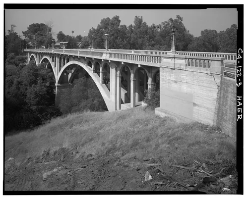
VIEW LOOKING NORTH ACROSS BRIDGE - Victoria Bridge, Spanning Tequesquite Arroyo, Riverside, Riverside County, CA
Easy
Georeferenced
Current Georeference
Image Details
- Source:
- Library of Congress
- Collection:
- Historic American Buildings Survey
- Date:
- Documentation compiled after 1968
- Description:
- Photo(s): 9 | Data Page(s): 7 | Photo Caption Page(s): 1 Subjects: citrus fruit industry, concrete piers, concrete balustrades, concrete arch bridges, transportation, vehicular bridges, street lights Locations: california, riverside, riverside county Notes: For additional information, see also California Citrus Heritage Recording Project (HAER CA-118). Significance: The Victoria Bridge was constructed to provide a convenient route between the agricultural and business areas of Riverside, becoming a vital link for transportation from the citrus groves to the packing houses. The bridge is also considered to be one of Riverside's most prominent architectural and engineering features. Survey number: HAER CA-122 Building/structure dates: 1928 Initial Construction Building/structure dates: 1980 Subsequent Work
- Source:
- Loading...
- License:
- United States Government Work
- Rating:
Georeference Details
- By:
- Dave Stolte
- Date:
- Jun 27, 2026
- Total:
- 1 submission
- Confidence:
- High
- Validations:
- 0
Actions
This image has been georeferenced. Login with OpenStreetMap to submit a correction.
Image Subjects

Timeline
All georeferencing activity and comments for this imageGeoreferenced by Dave Stolte Current
Jun 27, 2026 6:08 PM
33.960922, -117.370115
340°
High Confidence
0 validations